Sims Park / Enchantment Park
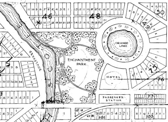
Sims Park has been the social centerpiece of New Port Richey for 114 years. It first appeared on a plat map submitted by the Port Richey Company in October of 1911. Owned by P. L. Weeks, a turpentine operator from Brooksville, his brother J. S. Weeks, and W. E. Guilford, the Port Richey Company knew that the primary sales features of the future town site were the Cotee River and nearby Orange Lake.
The proposed park area, originally named “Enchantment Park” extended from the river to Orange Lake, and was bordered on the north and south by what are now Sims Lane and Nebraska Avenue. None of the streets on the plat map are named, but we can see that what is now Main Street dead ends at the park, and it is Nebraska Street that is planned to span the Cotee River.
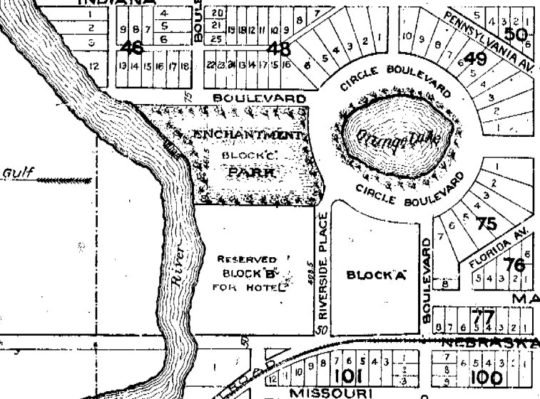
In February of 1913, the Port Richey Company and its property holdings were purchased by George Sims and a partner, R. E. Filcher. Filcher died in 1929, but Sims – who was the frontman for the company – went on to become known as a founding father of the City of New Port Richey.
After this change of ownership, a new plat was submitted for New Port Richey with named streets and a few other changes from the original 1911 map. The most noticeable difference between the two plans is that Enchantment Park is much smaller – with about half the south portion reserved for a hotel.
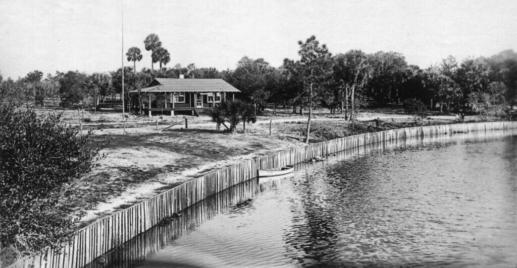
Even though the population of New Port Richey was reported to be only 100 people in 1915, the park was already becoming a center for social life in the community. George Sims built a clubhouse for the newly formed Cootie Community Club in Enchantment Park in 1916 (it later became known as the Woman’s Civic Club). That same year, a boathouse was completed on the riverbank in the park.
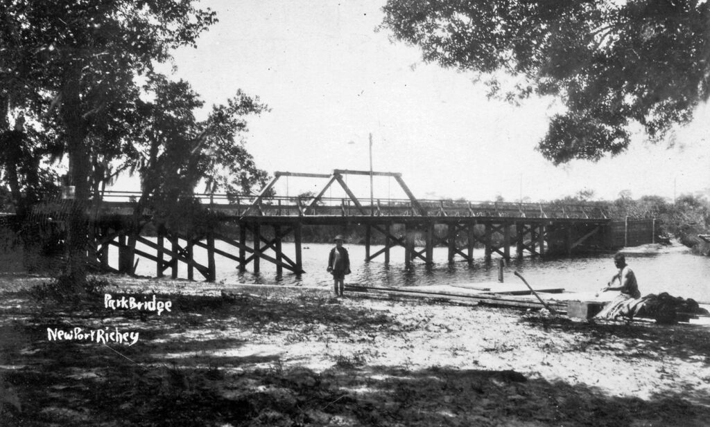
As early as 1915, the need for a bridge across the Cotee River had been discussed. A bridge was finally completed at the south side of the park property in 1920. It became known as the “Park Bridge”. On a current map of the area, you can see that there is a “Bridge Road” west of the river across from Sims Park. If you envision this road extending east over the river, you can see where the old bridge was located.
The Park Bridge was removed after completion of the Main Street Bridge in 1927.
Enchantment Park was the cultural hub for the entire New Port Richey community. Regular dances, picnics and other events were held in the park, and at the Community Club. A tennis court and croquet court were added in the early 1920s. In 1922, the first Chasco Fiesta was centered at Enchantment Park – a tradition that continues to this day.
When the City of New Port Richey was incorporated in October of 1924, George Sims donated Enchantment Park and the area around Orange Lake to the city. Ordinance One, adopted by the newly formed City Council, accepted this gift. And on December 16th of that year, the park was named “Sims Park” to honor George Sims.
In 1925, a bandstand was erected in Sims Park near the river. It was the center of many picnics and concerts in the park, and served as a venue for public speakers and politicians. It was moved to a location in front of the West Pasco Historical Society museum in 1983, and now serves as a gazebo where weddings and other events are held. The museum building itself is an old schoolhouse from Seven Springs built in 1915 that was relocated to Sims Park in 1981. It now serves as the Rao Musunuru, MD Museum & Library.
In the 1950s, a basketball court and concrete bleachers were added to the park. And in August of 1984 a new bandshell was added to replace the old bandstand.
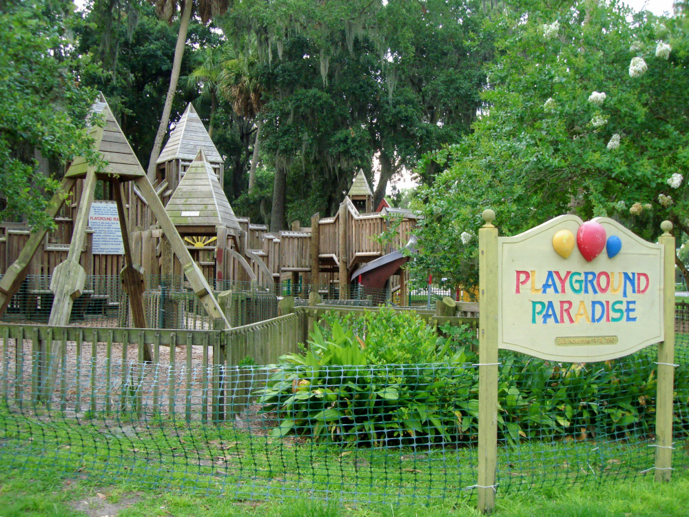
In more recent years, a “Super Playground” was constructed in Sims Park in November of 1992. The giant wooden playground covering 12,000 square feet was put together by over a thousand volunteers in less than a week.
In 2015, the Super Playground was torn down and replaced by a new playground and splash pad as part of a totally redesigned Sims Park that included a new bandshell. Grand Boulevard was re-routed and the the park was merged with the area around Orange Lake.
This article was written by Paul Herman, Digital Media Archivist, West Pasco Historical Society, and is based on an article published in the Suncoast News on July 2, 2025.